
Page 323 - Les Nouveaux Guides Géologiques et Miniers du Maroc - Volume 9
P. 323
Volume 9 - F:Mise en page 1 7/11/12 15:48 Page 323
9- Les mines du Moyen Atlas et de la Chaîne des Horsts /
The Mines in the Middle Atlas and Horsts Ranges
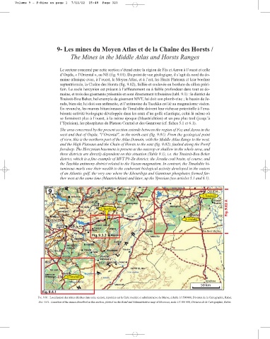
Le secteur concerné par cette section s’étend entre la région de Fès et Azrou à l’ouest et celle
d’Oujda, « l’Oriental », au NE (fig. 9.01). Du point de vue géologique, il s’agit du nord du do-
maine atlasique avec, à l’ouest, le Moyen Atlas, et à l’est, les Hauts Plateaux et leur bordure
septentrionale, la Chaîne des Horsts (fig. 9.02), faillée et soulevée en bordure du sillon préri-
fain. Le socle hercynien est présent à l’affleurement ou à faible profondeur dans tout ce do-
maine, et trois des gisements présentés en sont directement tributaires (tabl. 9.1) : le district de
Touissit-Bou Beker, bel exemple de gisement MVT, lui doit son plomb-zinc ; le bassin de Je-
rada, bien sûr, lui doit son anthracite, et l’antimoine du Tazekka est lié au magmatisme viséen.
En revanche, les marnes bitumineuses de Timahdite doivent leur richesse potentielle à l’exu-
bérante activité biologique développée dans les eaux d’un golfe atlantique, celui-là même où
se formèrent plus à l’ouest, à la même époque (Maastrichtien) et un peu plus tard (jusqu’à
l’Yprésien), les phosphates du Plateau Central et des Ganntour (cf. fiches 5.1 et 6.1).
The area concerned by the present section extends between the region of Fez and Azrou in the
west and that of Oujda, "l’Oriental", in the north-east (fig. 9.01). From the geological point
of view, this is the northern part of the Atlas Domain, with the Middle Atlas Range to the west,
and the High Plateaus and the Chain of Horsts to the east (fig. 9.02), faulted along the Prerif
foredeep. The Hercynian basement is present at the outcrop or shallow in the whole area, and
three districts are directly dependent on this situation (Table 9.1), i.e. the Touissit-Bou Beker
district, which is a fine example of MVT Pb-Zn district; the Jerada coal basin, of course, and
the Tazekka antimony district related to the Visean magmatism. In contrast, the Timahdite bi-
tuminous marls owe their wealth to the exuberant biological activity developed in the waters
of an Atlantic gulf, the very one where the Khouribga and Ganntour phosphates formed far-
ther west at the same time (Maastrichtian) and later, up the Ypresian (see articles 5.1 and 6.1).
FIG. 9.01 : Localisation des mines décrites dans cette section, reportées sur la Carte routière et administrative du Maroc, échelle 1/1500000, Division de la Cartographie, Rabat.
FIG. 9.01 : Location of the mines described in this section, plotted on the Road and Administrative map of Morocco, scale 1/1500000, Division de la Cartographie, Rabat.